 www.geodatenkatalog.de (S3L)
Keyword
Additional - Refugee / IDP - Contextual
2 record(s)
Provided by
Type of resources
Available actions
Topics
Keywords
Contact for the resource
Update frequencies
-
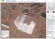
The Al Zaatari refugee camp in Jordan is situated approx. 12 km from the Syrian border and in close proximity to the city of Al Mafraq (10 km). Due to heavy rainfall in the region parts of the Zaatari camp are affected by flooding. The map shows the flood situation derived by semi-automatic image analysis of TerraSAR-X data acquired on January 10, 2013 at 03:38:49 UTC. Furthermore basic reference information, digitized on the basis of WorldView-2 satellite data acquired on January 03, 2013, at 08:52:52 UTC, is depicted. The contour lines were derived from ASTER GDEM 2 data (vertical accuracy +/- 6m). For a more detailed view on the flood situation, parts of the camp area are also shown in the zoom boxes. The results of the image interpretation and analysis have not been validated in the field. WorldView-2 satellite data acquired on January 03, 2013, is used as backdrop. Please note that flood waters in settlement areas might not be fully captured and the water extent might be underestimated due to sensor characteristics. Thus especially shallow water bodies might not be fully captured. The products elaborated for this Rapid Mapping Activity are realised to the best of our ability, within a very short time frame, optimising the material available. All geographic information has limitations due to the scale, resolution, date and interpretation of the original source materials. No liability concerning the content or the use thereof is assumed by the producer. The ZKI crisis maps are constantly updated. Please make sure to visit http://www.zki.dlr.de for the latest version of this product.
-
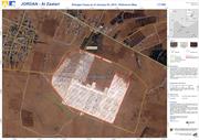
The map shows the Al Zaatari refugee camp in Jordan. It is situated approx. 12 km from the Syrian border and in close proximity to the city of Al Mafraq (10 km). The camp was set up on July 28, 2012 to shelter refugees fleeing the conflict in Syria. The vector data have been digitized on the basis of WorldView-2 satellite data (0.5m spatial resolution) acquired on January 03, 2013. The results have not been validated in the field. WorldView-2 satellite data acquired on January 03, 2013 is used as backdrop. The products elaborated for this Rapid Mapping Activity are realised to the best of our ability, within a very short time frame, optimising the material available. All geographic information has limitations due to the scale, resolution, date and interpretation of the original source materials. No liability concerning the content or the use thereof is assumed by the producer. The ZKI crisis maps are constantly updated. Please make sure to visit http://www.zki.dlr.de for the latest version of this product.